Esri Maps for Office

February 26, 2012

Easily create dynamic, interactive maps of your Excel information and start exploring your data in a whole new way.

Esri Maps for Office enables you to drill into your Excel information on maps, to uncover patterns and trends not evident in tabular data and charts. The process of creating a map in Excel is painless, and is much the same as creating a graph or chart of your data.

Maps can be shared immediately through PowerPoint presentations or by one-click publishing to Esri’s mapping cloud, ArcGIS Online.

Esri Maps for Office is an add-in to Microsoft Office and will be available in public beta the first half of 2012.


The Future Looks Bright for Spatial Thinkers

February 22, 2012

As the reach of spatial information expands, new opportunities are created for spatial thinkers in many areas.

Many industries have suffered during the current economic downturn. So why is it that during this same period, demand for geospatial technology professionals has grown significantly?

I think that this trend is due to the growing understanding of the value of spatial information and analysis.

There are many reasons to implement GIS, but the benefits that we see driving organizations in lean times are cost savings resulting from greater efficiency. And as we come out of this economic downturn, the efficiencies realized from GIS will become a standard way of doing business, so the need for geospatial professionals will increase even more.

Government has long been at the forefront of this movement, and there will be opportunities here for people with geospatial knowledge, most notably in the area of national security and in anything to do with increased transparency and accountability. But we’re now seeing a huge shift in momentum in the commercial arena. Many of the future career opportunities for geospatial professionals will be in the private sector, as businesses increasingly realize the benefits that government has understood for some time.

The current high unemployment rate is sending a lot of experienced workers “back to school” to learn new skills more relevant for the 21st century workplace. This is one factor driving the growth of focused geospatial programs at universities and community colleges, both at the degree level and the certificate level. These programs are doing a great service by training the geospatial workforce of tomorrow. They are also providing many opportunities for seasoned geospatial professionals to take on new roles themselves—passing on their vast knowledge by instructing and teaching the next generation of geospatial professionals.

But the career opportunities here are not just for the people who sit in front of keyboards and “do GIS”. It’s much bigger than that. I think that the real growth opportunity is in the area of spatial thinking. As people in all types of positions become more familiar with the value of geography, they begin to ask more intelligent questions about the world, and they begin to make more informed decisions. The coming opportunities for spatial thinkers will be even greater than those we are seeing for geospatial technology professionals.


MIT’s Free Urban Planning Software Will Help Build The Cities Of The Future

February 19, 2012

If we are to improve the quality of life in our cities – 27 of which are expected to have more than 10 million people by 2020 – we will have to find a better way to build them. MIT’s new software will help.

Most of the world lives in cities. That number, now at about 3.3 billion people, will keep going up. During the next five years, urban populations are expected to soar well beyond half the world’s total.

Yet most of those urbanites are also likely to live in poorly, or at least haphazardly, designed cities. The expertise to create a well-planned metropolis is seldom available, especially in the developing world, where 30% of urban populations live in informal slums. Globally, 70% of today’s urban growth occurs outside the formal planning process. If nothing changes, the inefficiencies, pollution, and misery of modern dysfunctional cities may become the norm.

Avoiding that future just became a bit easier with the launch of the Urban Network Analysis, an open-source software released by MIT. Taking a cue from social networks and mathematical network analysis methods, the City Form Research Group’s program calculates how a cities’ spatial layout affects the way people will live in it.

It measures traits such as “reach, gravity, betweeness, closeness, and straightness,” which, in laymen terms, express features such as the number of services, buildings, and resources within a certain walking distance, or the volume of traffic along sidewalks and streets. Designers can also assign characteristics to individual buildings, as well as track urban growth and change with analytic support for policy makers.

What this means is that city planners can look at their cities and see, for instance, that some neighborhoods are closer to jobs than others (the map at the top is the “reach” map for jobs in Cambridge, MA. Red means closer to jobs). Knowing this, planners might want to build transportation from green areas to red areas. It can also predict things like street traffic: Good to know if you want to create a commercial zone where you will need walk-in customers.

Until now, claims MIT, no free tools were available for city planners to tackle the tough computational challenges of characterizing the dense tangle of streets, buildings, and transport in modern cities. MIT hopes the UNA toolbox, an open-source plug-in for the ArcGIS mapping program, will enable urban designers, architects, planners, and geographers around the world to better understand how the spatial patterns of cities will affect the way people live and move around their urban environments.


GIS Cloud – GIS Mapping Software to Visualize & Publish Maps

February 19, 2012


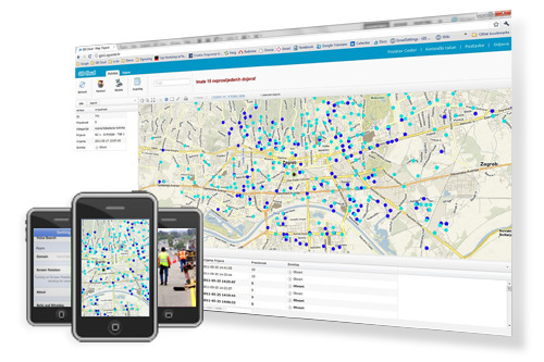
GIS Cloud is web based mapping software and platform. You can visualize, analyze, share, publish and manage GIS projects, maps and geospatial data online.
Via www.giscloud.com


CERN Repeats Faster-than-Light Experiment, Gets Same Result

February 19, 2012

A second experiment clocking the speed of subatomic particles using a GPS timing receiver has reconfirmed the revolutionary September results — the neutrinos moved faster than the speed of light, according to an announcement from the European Organization for Nuclear Research (CERN).

“One key test was to repeat the measurement with very short beam pulses from CERN,” the agency noted in a press release on its website. “This allowed the extraction time of the protons, that ultimately lead to the neutrino beam, to be measured more precisely…  The new measurements do not change the initial conclusion.

Septentrio’s precise-timing GPS receiver PolaRx2eTR features prominently in the OPERA experiment. Following the OPERA collaboration’s presentation at CERN on September 23, inviting scrutiny of their neutrino time-of-flight measurement from the broader particle physics community, the collaboration has rechecked many aspects of its analysis and taken into account valuable suggestions from a wide range of sources, CERN stated on its website.

The beam sent from CERN consisted of pulses three nanoseconds long separated by up to 524 nanoseconds. Some 20 clean neutrino events were measured at the Gran Sasso Laboratory, and precisely associated with the pulse leaving CERN. This test confirms the accuracy of OPERA’s timing measurement, ruling out one potential source of systematic error.

“Nevertheless, the observed anomaly in the neutrinos’ time of flight from CERN to Gran Sasso still needs further scrutiny and independent measurement before it can be refuted or confirmed,” CERN stated.

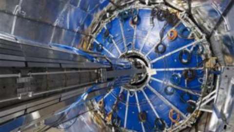
The OPERA experiment observes a neutrino beam from CERN 730 kilometers away at Italy’s INFN Gran Sasso Laboratory. The OPERA result is based on the observation of more than 15,000 neutrino events measured at Gran Sasso, and appears to indicate that the neutrinos travel at a velocity 20 parts per million above the speed of light, nature’s cosmic speed limit.

“Given the potential far-reaching consequences of such a result, independent measurements are needed before the effect can either be refuted or firmly established. This is why the OPERA collaboration has decided to open the result to broader scrutiny,” CERN stated.